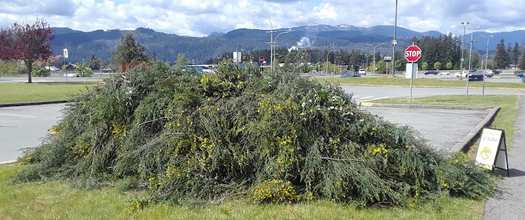
I went out with the Port Alberni Broombusters today. Given arthritis, and my degenerating discs, I couldn't bend down to cut, or bend down to pick up the cut broom, so I just ran back and forth, carrying messages, getting axes and other equipment, and so forth. Still not completely useless ...
Apparently, however, I covered eight kilometres in so doing ...
The cut was around the North Island College campus. And we're still not completely finished behind the college ...
After the cut, I headed down to the library, to turn in some materials. And got caught out, despite *three* weather forecasts having promised that we wouldn't have any rain, by a huge storm cell over North Southport[*] pouring rain between the library and my place!
But I had a half a dozen Economist magazines with me, so I read one to give the rain time to figure out what it was doing.
It cleared up at the library, so I headed off, and it was OK for three blocks, but just a block before I got to Redford, I got caught in a hail storm. So I had lunch at McDonald's, hoping that by the time I finished lunch it might be a bit clearer.
Had lunch. Checked outside: blazing sun. I left McDonalds, checked the sky, clear blue over the whole of PA. Walked a block, *HUGE* storm cell forming over North Southport[*]. Managed to get home before it let go: so far it hasn't, yet ...
[*] - OK, for those of you who aren't familiar with the place (and for those of you who said you'd never been to Port Alberni, but you *had* been to Tofino, and apparently never realized that you had to go *through* Port Alberni to *get* to Tofino: that you probably stopped for *gas* in Port Alberni) I suppose I have to explain the lay of the land.
Port Alberni is smack-dab in the middle of Vancouver Island (which, if you were not paying attention in geography class, is roughly the same size as Denmark or Maine), and yet, because of Barclay Sound, is actually a deepwater port on the Pacific Ocean.
Port Alberni is formed of *two* former cities (Alberni and Port Alberni), and, like Gaul, is divided into three parts. The natural division of the place is geographic: two greenbelts running east and west through the whole town, along the two creeks, Roger Creek, and Dry Creek. There are a couple of places to cross each creek on foot, but, if you want to drive (and, remember, I am the *only* pedestrian in Port Alberni) is at Third or at Tenth across Dry Creek, or at Maebelle (which is basically where Highway 4 joins Highway 4A) or at Gertrude (which is basically Third, except that it isn't).
So we have Northport, which is basically what *was* Alberni. This is north of Roger Creek. Then we have Southport, which is what basically *was* Port Alberni. Except that is has the Dry Creek greenbelt running right through it. So then we have *North* Southport, between Roger Creek and Dry Creek, and we have *South* Southport, south of Dry Creek.
Community Policing has simplified all of this, with Zones 1, 2, and 3. Except that Zone 1 is north of Roger *Street*, which means that a strip, running east and west across the whole of Port Alberni, several blocks wide, is in Zone 1, but you have no way to get to the rest of Zone 1, because Roger *Creek* is in the way. Similarly, Zone 2 extends from Roger Street to Argyle Street. But Argyle Street is, again, south of Dry Creek, so we have strip, running east and west across the whole of Port Alberni, a few blocks wide, in Zone 2 with no way to get to the rest of Zone 2.
I hope that this is all now quite clear.


No comments:
Post a Comment